TRAIL NEWS AND INFORMATION
Woodside Trail Group, Fall 2026 Hiking Program
TRAIL NEWS
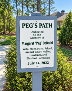
We have added a nice new trail to the Woodside trail system. This involves Pegs Path and the new access point to the Hollow Creek Trail that is located on Anderson Mill Road. Please see the attachment or go to our website for more information. See WOODSIDE TRAIL WALKER – Home
The section of the Hollow Creek trail along the fenceline separating the homesites in the “Perimeter” home development area has now been rerouted deeper into the woods. It now skirts the lower of the two twin ponds and gives nice views and access to the lower pond. A great improvement! Thank you, Scott Leycett, and the development company for doing this.
Augusta Canal Trail
When: 10/24/26 at 9:30 am
Hike Leader: Debby Smist, debsmist@gmail.com, 413-204-8146
Description: A beautiful walk along the towpath with the Savannah River on one side and Augusta Canal on the other. The path, which was once used by mules to pull canal cargo boats upstream, is flat, hard packed sand-clay and mostly shaded.
Meeting Place: Savannah Rapids Park, 3300 Evans to Locks Rd, Martinez, GA. Park in the lot to your immediate right after entering the park. The meeting point is approximately a 40–45-minute drive from Woodside.
Distance: 4 to 5 miles. Out-and-back path so you can turn around if you want a shorter walk.
Terrain: Flat.
Bring: Water and wear good sneakers or boots. Perhaps a walking stick.
— Rain Cancels —
Hitchcock Woods
When – Saturday, November 14th, 2026, 10:00 am
Hike Leader – Dave Lehman, email: davelehmam181@gmail.com, Mobile Phone: 407-625-4944
Description – Dave is a new hike leader for the Woodside Trail Group, so come out to support him as he leads this 2.5-mile hike. The route uses the Cuthbert Ridge Line trail, then descends to Crazy Creek where it crosses the bridge onto Doll Lane. Turning left onto Doll Lane, it proceeds to the Cavalry Charge trail where it crosses Crazy Creek once more and climbs out of the valley to join the Old County Road trail and hence back onto Cuthbert Ridge Line. At the Mockingbird Hill clearing, it proceeds along the 1977 Burn trail and then back to the Clarks Road starting point. The trail is mostly level but does have a 125-foot gradual descent to Crazy Creek’s valley and a steeper climb back out of the valley on the Calvary Charge trail. There are nice views as you descend to Crazy Creek. You can read more about the hike and see a map in the following link:
Hitchcock Woods Clark Road Entrance, South Carolina – 318 Reviews, Map | AllTrails
Meeting Place – The Clark Road entrance to Hitchcock Woods.
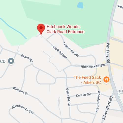
Meeting Time – 9:45 am so that we can begin the hike at 10:00 am. Parking is tight at the trailhead, so consider parking along Clark Road and walking the short distance to the trailhead.
Distance – 2.5 miles
Terrain – Mostly level with sand underfoot. There is some downhill to Crazy Creek and then a steeper climb of about 175 feet of altitude out of the valley.
Bring: Water and wear good sneakers or boots. Perhaps a walking stick and camera
Rain cancels
Barnwell State Park
When – Saturday, December 5, 2026, 10:00 am
Hike Leaders – Tracy & Dick Spaeth, email – rhspaeth@gmail.com, text – 585-727-4212
Description – There are two 1.5-mile hikes.
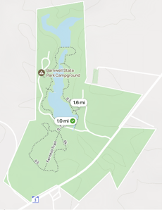
Dogwood Interpretive Trail, 1.5 MILE LOOP, INTERPRETIVE TRAIL, EASY
Though perhaps best known for its fine fishing and a popular community recreation center, Barnwell State Park also includes this easy 1.5-mile loop trail which encircles the southernmost of two lakes. The trail begins behind the park office.
Fern Hill Nature Trail – 1.5-mile loop, Nature Trail, Easy
The Fernhill Nature Trail gets its name from the thousands of ferns located alongside many portions of the trail. In December, you will not see the ferns, nor the many other flowering plants that grow along the trail, such as yellow jasmine, partridgeberry, and butterfly weed, that you would encounter at other times of year. But you will see Spanish moss and enjoy the winter landscape. On this trail, you can see the troughs and elevation changes created by Barnwell State Park’s watershed leading back to the three lakes in the park. You will also experience the regrowth of a forest after the tornado that occurred here in January 2016. There are geocaches located in the park, and we might find one! (GC6R5QM)We plan to do both hikes, but you have the option of only doing one.
Meeting Place – Barnwell State Park, 223 State Park Road, Blackville, SC 29817. Meet at the Park Office. It is approximately a 50-minute drive from Woodside.
Meeting Time – 9:45 am so that we can begin the hike at 10:00 am
Distance – We will hike a total of 3 miles.
Terrain – Easy, gentle
Lunch – Lunch following the hike for those who desire – 12:00 PM – Miller’s Breadbasket, 483 Main St, Blackville, SC 29817. It is an Amish/Mennonite restaurant with home cooking. If you wish to have lunch, please contact Tracy & Dick no later than December 1, as they will need a head count to make the lunch reservation.
Bring: Water and wear good sneakers or boots. Perhaps a walking stick.
Seventh Annual Clear the Cobwebs Hike
When: Friday, Jan 1, 2027, at 1.45 pm for 2.00 pm start
Hike Leader: Jim Pierce; 803-634-0513; jbpierce649@outlook.com
Description: January 1 is widely celebrated as “First Day Hikes,” a nationwide tradition that functions as the de facto National Hiking Day for New Year’s Day. It’s not an official federal holiday, but it is a coordinated national event across all 50 states. So come out and clear your New Year’s Eve cobwebs on our version of the National Hiking Day by joining our annual “Clear the Cobwebs” hike. We will take an easy-going 2-mile jaunt around Woodside’s Oakman Trail. This would also be a great hike to introduce any New Year’s visitors to one of Woodside’s most pleasant walks. After the hike, we will all stop to toast the New Year. Suitable beverages will be provided by the hike leader and, as in past years, we hope we will have cookie donations from some of those participating in the hike. The big picnic table located where we used to stop for these celebrations has rotted out and been removed. However, Rick and Martha Funk, the trail captains for the Oakman Trail, have graciously agreed to supply a suitable table for our refreshments. Dogs on a leash are welcome, but you must supply your own doggy cookies! Put this outing on your calendar now!
Meeting Place: We will meet in the “parking area” just off the road leading to the Reserve Club golf maintenance shed. This is very close to the junction of West Pleasant Colony, East Pleasant Colony, and Woodside Plantation Drive. Signs point out the way. If you find parking tight, you can also park along the maintenance road. If you bring cookies, you might want to arrive early and take them to the picnic table and begin your hike there.
Distance: About 2 miles
Terrain: A couple of ups and downs but mainly flat, easy walking.
Bring: Water and wear good sneakers or boots. Perhaps a walking stick. If it rains before the hike, the trail may have wet sections.
— Rain Cancels —